Top-Rated Kruger National Park Safaris in South Africa
Private, Family-Friendly, and Luxury Safari Packages. Rated 5-Stars on TripAdvisor.
Featured Safaris
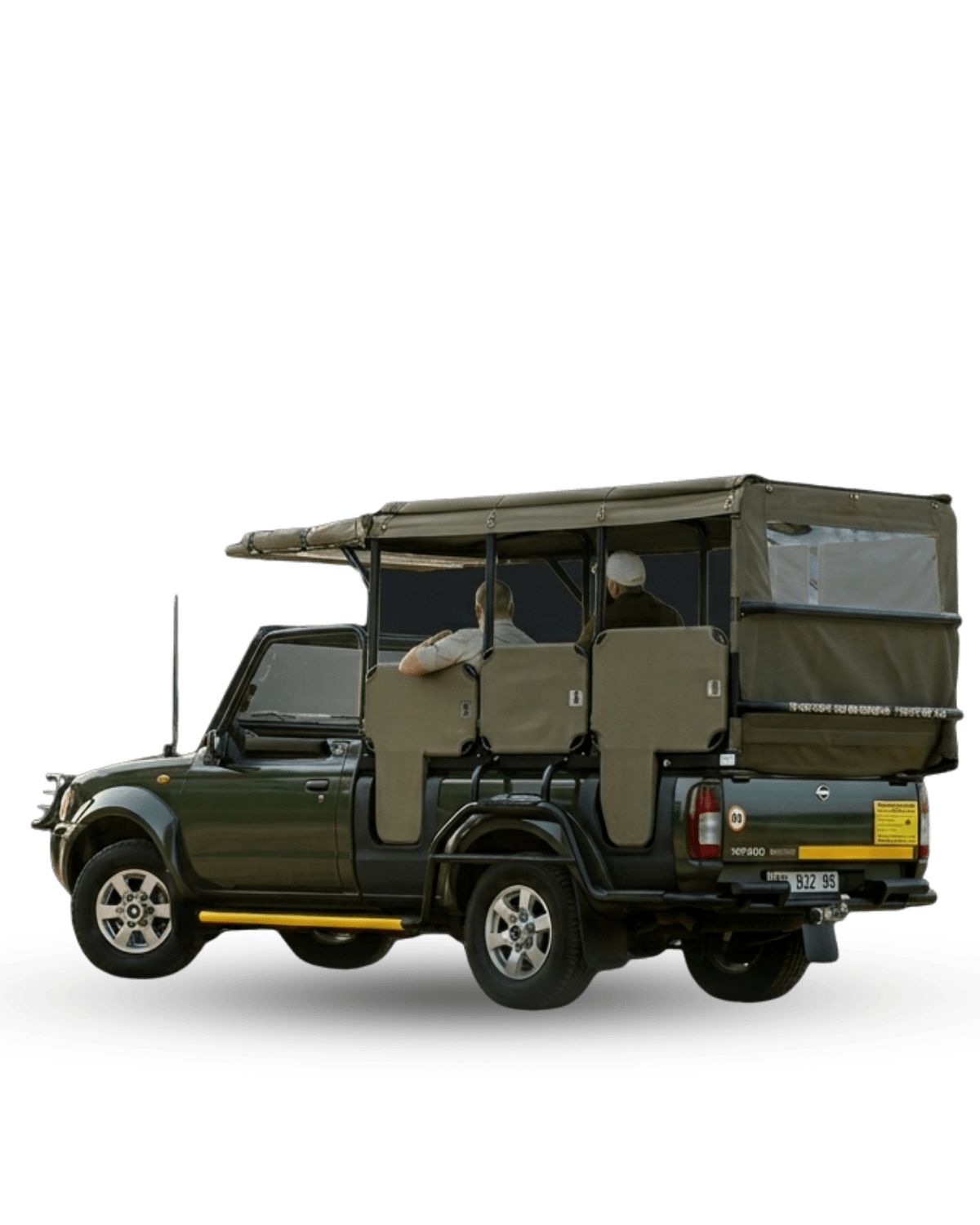
Discover our signature collection of hand-picked itineraries, designed to showcase the very best of the Greater Kruger National Park. From budget-friendly adventures to exclusive luxury escapes, these premier Kruger Park safaris offer unrivaled wildlife encounters led by the industry’s top-rated professional guides.
Kruger Day Trips
Experience the best of South Africa’s premier wildlife destination in a single day. Our Kruger Park day trips offer an intensive search for the Big Five, led by expert guides through the park’s most productive game-viewing regions.
Budget Kruger Safaris
Embark on an authentic African adventure without breaking the bank. These budget-friendly Kruger Park safaris prioritize incredible wildlife encounters and professional guiding, offering a comfortable and affordable entry into the heart of the wild.
Comfort Kruger Safaris
The perfect balance of rugged exploration and refined relaxation. Our comfort safaris provide upgraded lodge accommodation and hand-picked amenities, ensuring you enjoy the raw beauty of a Kruger Park safari with an extra touch of hospitality.
Luxury Kruger Safaris
Indulge in the ultimate wilderness retreat. Featuring world-class private lodges and exclusive game drives, our luxury Kruger Park safaris offer a sophisticated, tailor-made experience for those seeking privacy and unparalleled comfort in the bush.

Welcome To
Nhongo Safaris
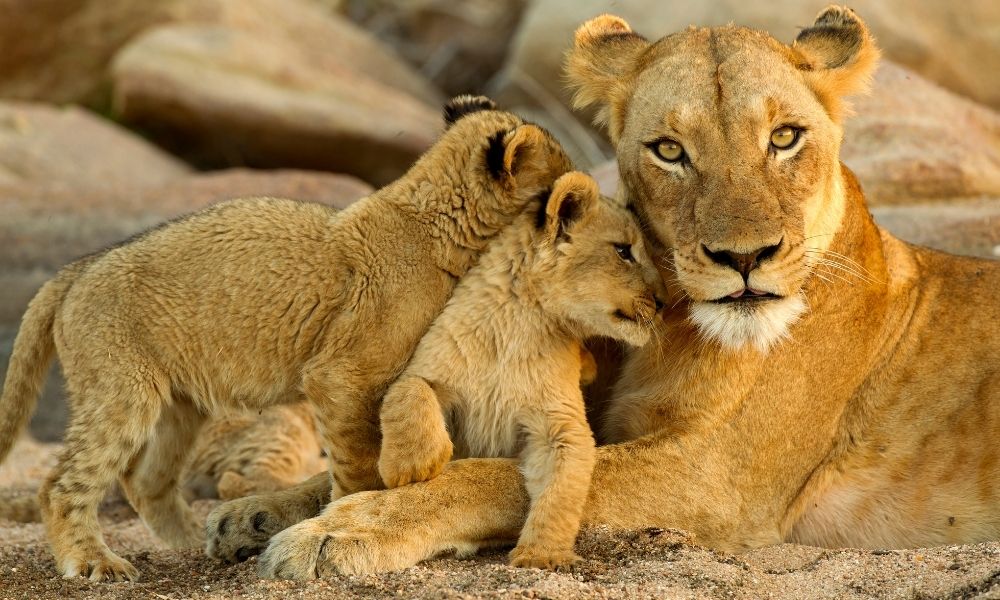
Welcome to Nhongo Safaris, the premier provider of authentic Kruger Park Safaris since 1999. Our expert-led tours immerse you in South Africa’s untamed wilderness, offering an unparalleled opportunity to track the legendary Big Five with passionate naturalists. Whether you are traveling from Europe, Asia, or Australia, we ensure a seamless wildlife experience from your initial booking to your final bush encounter.
Years Experience
Safaris Completed
Cups of Coffee
Discover Our Most Popular Safari Packages
Not sure where to start? We’ve gathered our most requested, traveler-favorite safari packages right here. These tried-and-tested itineraries are designed to maximize your time in the magnificent Kruger National Park, offering unforgettable wildlife encounters and authentic bush experiences. From short, action-packed adventures to extended explorations, these packages represent the very best of what Nhongo Safaris has to offer. Find your perfect journey below.
3 Day Classic Kruger
Safari
Perfect for travelers on a tight schedule, our 3-Day Classic Safari offers a whirlwind adventure into the heart of Kruger National Park. This action-packed tour includes multiple game drives led by our expert guides, maximizing your chances of spotting the legendary Big Five.
- Kruger National Park
- 3 Days
- 2 People
R15 000
4 Day Budget Kruger
Safari
This safari provides a rustic yet comfortable experience, perfect for those who want to immerse themselves in nature and make the most of their Kruger adventure. With multiple game drives included, you’ll have plenty of opportunities to spot the Big Five and other amazing animals.
- Kruger National Park
- 4 Days
- 2 People
R13 500
4 Day Luxury Skukuza Safari
The pinnacle of a premium wildlife experience, based at the elegant Skukuza Safari Lodge right inside Kruger National Park. This exclusive package features comfortable transfers from Johannesburg, and guided open vehicle game drives focused on spotting the Big Five.
- Kruger National Park
- 4 Days
- 2 People
R21 950
Why Choose Us?
Choosing the right safari partner is the first step toward an unforgettable African journey. At Nhongo Safaris, we believe your focus should be on the majesty of the wilderness, not the logistics of your trip. When you choose us, you’re not just booking a tour, you’re securing a hassle-free, deeply immersive adventure where every detail is handled with precision and passion.
Expert Guides
Our Guides Are Professional, knowledgeable, and passionate about African wildlife.
Customizable Tours
Tailor your itinerary, activities, and accommodations to perfectly match your personal interests and budget.
All-Inclusive Packages
We eliminate the stress of planning, offering a seamlessly all-inclusive adventure of a lifetime
Global Travel. Local Expertise
We understand that planning a journey to our corner of the world requires precise knowledge of international travel logistics, visa requirements, and cultural expectations. Our Local Expertise in the South African bush is perfectly matched by our Global Travel network, ensuring that no matter where you are planning your trip from, your path to an incredible Big Five safari is clear and stress-free.
We proudly welcome adventurers from every continent, bringing the world to the wonder of the wild.

North America
Visitors originating from the USA and Canada benefit from easy access to Kruger via direct flights to Johannesburg.

Europe
Whether you're traveling from the UK, Germany, France, Spain, or Italy, we offer tailored packages with convenient connections.

Asia
Safari enthusiasts from China, India, Japan, and South Korea can explore Africa’s Big Five with expert-guided tours.

Australia
From Australia and New Zealand, we ensures a seamless journey to the thrilling heart of your Kruger safari.

South America
Travelers from Brazil, Argentina, and beyond can embark on a once-in-a-lifetime journey to Kruger National Park.

Africa
Travelers from across Africa can effortlessly connect to their premium Kruger National Park safaris.
Voices from the Bushveld
We believe the truest measure of a great Kruger National Park safari is the experience of the traveler. Dive into the Kruger safari reviews from our global community who have experienced the thrill of a Big Five safari and the seamless service of Nhongo Safaris.
Verified Excellent Safari Experience Nhongo Safaris was our first experience in South Africa and it was one that we will never forget. The owners were fabulous with communication about transportation and getting us out to see as many animals as we possibly could during our short time there. Extremely nice people and this is for sure a place that we will return to in the future!Verified Excellent. We did the 3 days kruger gate safari,and it was the ideal short break from our buay lives.We stayed at lovely accommodation right near the kruger gate, which made it easy to get into the park each early morning.Our guide was excellent.The food taste is also so good.Verified 3 Day Kruger Gate Safari. Great We did the 3 Day Kruger Gate Safari, and it was the ideal short break from our busy lives. We stayed at lovely accommodation right near the Kruger Gate, which made it easy to get into the park early each morning.Our guide was excellent, he knew so much about animal behaviour and helped us spot lions, elephants, and even a cheetah. Each drive felt exciting, but also relaxed.The food was great, the vehicle was comfortable, and everything was so well planned. If you only have a few days but want a real taste of Kruger National Park, this is the perfect safari. We would absolutely recommend it.Verified A life-changing safari – truly the best we’ve experienced We’ve been on safari before, but this 5 Day African Kruger Safari was in a league of its own. Our itinerary included stays at Pretoriuskop, Letaba, and Skukuza Camps, each offering different ecosystems and scenery.Gift, our guide, was the heart of the experience – incredibly insightful, humble, and truly passionate about the wildlife. He helped us track a pride of lions one morning and later explained bird calls that led us to a leopard sighting. Every drive felt like a well-guided story through the bush.Gift also gave us time to simply enjoy the moments – no rushing, just being present. This was more than just a holiday – it was a journey into the soul of Kruger, and we’re so grateful to Gift and the Nhongo team for making it happen.Verified The perfect way to explore Kruger for first-time visitors This was our first safari and Nhongo Safaris made it unforgettable. Everything was organized and ran smoothly from the moment we were picked up. We were based at Pretoriuskop Camp, which had peaceful surrounds and excellent facilities.Gift, our guide, brought the whole experience to life with his deep knowledge of the park and incredible spotting skills. His respect for the animals and the park itself was evident in everything he did On one drive, he managed to find a leopard lounging in a tree – something we’ll never forget. We left with a deeper appreciation for the bush and a desire to return. Thank you, Gift and Nhongo, for such a memorable experience.Verified Wildlife, comfort, and world-class guiding I can’t recommend Nhongo Safaris enough. We had three unforgettable days in Kruger, staying at Pretoriuskop Camp, with wildlife right outside the fence and beautiful evening sounds from the bush.Our guide, Gift, was outstanding – calm, patient, and incredibly experienced. His ability to track and spot animals was nothing short of amazing. We saw lions, giraffes, buffalo, and even a cheetah! He answered every question with enthusiasm and taught us so much about animal behaviour.We especially loved the coffee stops during sunrise drives and the relaxed pace of the experience. Gift made us feel safe, welcome, and truly part of the adventure.Verified A seamless and unforgettable safari experience From start to finish, this 3 Day Classic Safari was absolutely outstanding. The pickup in Johannesburg was punctual and professional, and our guide, Gift, made us feel relaxed and welcome from the get-go. We stayed at Pretoriuskop Rest Camp, which was comfortable and surrounded by nature.The game drives were the absolute highlight – we saw the Big Five within the first two days. Gift was incredibly knowledgeable, sharing fascinating facts and spotting animals we never would have seen on our own. His passion for the bush is infectious.This was our first time in South Africa and our first safari – we couldn’t have asked for a better introduction to the Kruger National Park.Highly recommended.Verified Absolute perfection! Everything was absolute perfection! From the planning of our trip, the communication, the coordination, the safaris themselves, was planned and executed perfectly!Verity and Dean were both fantastic to work with. Verity was so patient with all our questions and they both responded in a timely manner even wuth the time difference and being out in the bush. Nhongo Safari was recommended to us and we couldn't have been happier with the choice to work with them. I loved that everything was coordinated from our airport pickup, pickup at the gate the KNP and getting us to and from our hotel. (Krugergate Hotel which was also amazing). Our guide Gift was fabulous! He was so knowledgeable and his love the environment shone through with how he shared all his knowledge with us. It wasn't just pointing out the Big 5 or the birds, or vegetation but hearing the background and him teaching us about the surroundings really made the trip special and gave us an even deeper appreciation of where we were. It was the trip of a lifetime for sure and I am so thankful for it. We would highly recommended Nhongo Safari to anyone looking for visit any time soon.Verified Beautiful and amazing!!! Amazing!!! Thanks to Verity for our special requests and for the organization and miles thanks to Robbie: the best Guide ever!!! Let me explain why:2 afternoon and morning safaris + transfer johannesburg- kruger Park with affordable accommodation. We saw: hippos, crocodile, guru, impala, giraffes, warthog, lion, hyena, cheetah, mongoose, eagle, zebra all Ave u. Beautiful sunset and sunrise😍😍😍😍 and see an elephant swimming like a hippo and charging at the drinking zebras, laughing hyenas, giraffes running, laughing hyenas, and the lion walking right at. With us. The tour safe and explanation.👏👏👏👏 In short we do not ask too much me and my family (2 adults + 2 children 8 and 12 years). So I recommend a thousand times if you have a tight budget and not much time you will not regret it!! If I could put more than 5 stars I would have put it without hesitation.Tripadvisor rating score: 4.9 of 5, based on 686 reviewsVerified by TrustindexTrustindex verified badge is the Universal Symbol of Trust. Only the greatest companies can get the verified badge who has a review score above 4.5, based on customer reviews over the past 12 months. Read more
Our Latest News
Kruger National Park Prices 2026: What to Expect This Year
Planning a trip to Kruger National Park in 2026? Discover the latest Kruger National Park prices 2026 and insights…
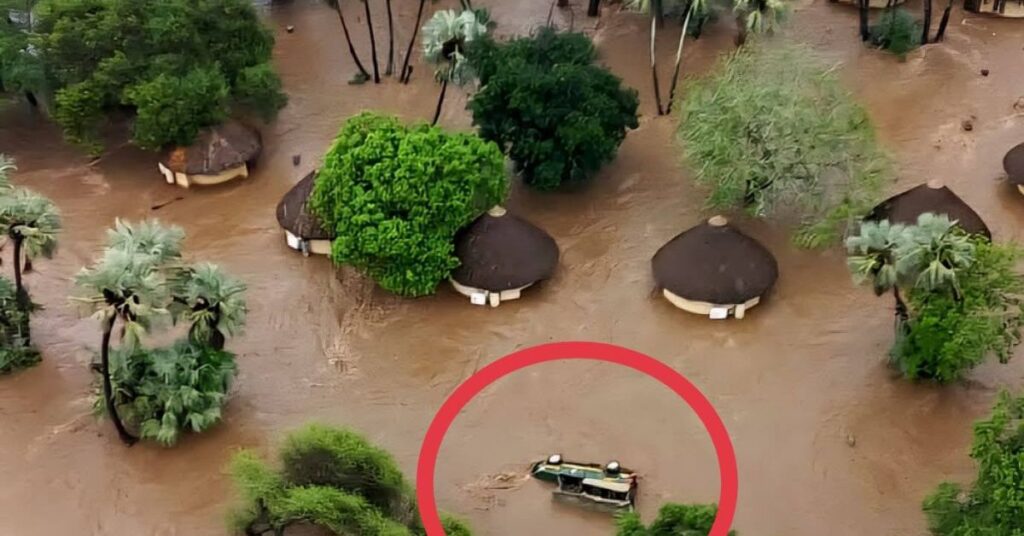
2026 Kruger National Park Floods: Impact and Recovery
The January 2026 floods in Kruger National Park (KNP) have become a landmark event in the park’s century-long history.…
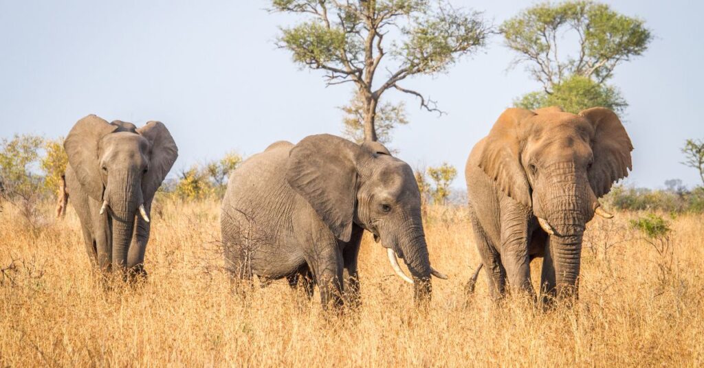
What It’s Like To See Your First Elephant
Seeing your first elephant in the wild is an awe-inspiring experience that combines a sense of grandeur with a…
Book Your Kruger Adventure Online
Book your adventure today and let Nhongo Safaris guide you through an unforgettable journey!